Highlights of the trip
- Conquer one of the favorite acclimatization peaks
- Epic sceneries of the titanic Alay mountains
- Prestine nature
- Nomadic and rural lifestyles
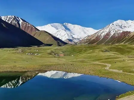
Discover one of the best trekking routes in the trekking utopia of Central Asia that culminates with the conquest of Yukhin Peak – one of the best acclimatization peaks and get a close-up view of Lenin Peak. Don’t miss the opportunity to experience the high-altitude beauty of the Pamir Mountains.
Tour Details
Available
June (mid) - Early September
Schedule
Upon request
Duration
8 days
Price
upon request
Difficulty
Challenging
Required items
Trekking boots (+light shoes), weatherproof warm clothes, hat, gloves, sunscreen, sunglasses, sleeping bags
Itinerary (click to unfold the description)
Welcome to Osh. See you at the airport or at your hotel before you depart for Kojo-Kelen village. The beauty of Kyrgyzstan’s nature is evident from the moment you see its exotic mountains, flora, and fauna. The road will take you along the Papan reservoir, the main source of drinking and irrigation water in Osh. After 3.5 hours of driving, you will reach the Kojo-Kelen (2230 meters). A welcoming lunch will be waiting for you upon arrival, before you head out for an acclimatization hike (2-3 hours). You will visit the Blue Grot and the waterfall. Return to the guest house for dinner and overnight.
- Accommodation type: homestays with shared rooms and traditional floor mattress beds; hot shower and water running toilets
- Food: homemade lunch and dinner at the guesthouse
- Electricity and network: electricity is available, mobile network (megacom), and wifi
- Driving distance: 95 km, 3 hours
- Ascend/descend: 2260/1050 meters
- Highest and lowest points: 2230/980 meters
- Overnight altitude: 2230 meters
Start your journey on the slopes of the beautiful Cretaceous mountains of Kichik-Alai (Minor Alay Mountains). You will cross the Sary-Bel Pass (3150m) and walk to the camp in Kosh-Moinok. The term means “Two Pastures,” reflecting the pastoral nature of the local landscape and people. The area is renowned for its stunning mountain scenery, which offers peace and tranquility.
- Accommodation type: shared yurt stays with traditional floor mattress beds; solar shower and flush toilets
- Food: lunch en route and dinner prepared by the yurt hosts.
- Electricity and network: not available
- Trekking distance: 12 km, 7-8 hours
- Ascend/descend: 1010/350 meters
- Highest and lowest points: 3130/2190 meters
- Overnight altitude: 2822 meters
After a little passage from Kyzyl-Chara, there is a small village called Sary-Mogul. From here, we will head to the south, going along the mountain river surrounded by cliffs, subalpine, and alpine meadows. All this represents the rich diversity of Kyrgyz landscapes. Besides nature, you will hear the crying marmots and birds singing. You will see large birds such as vultures, golden eagles, owls, and hawks floating in the sky. As the area is also inhabited by mammals such as wolves, foxes, badgers, wild boars, mountain goats, and jackals, you may find traces of them.
Relax upon arrival at the yurt camp.
- Accommodation type: homestays with shared rooms and traditional floor mattress beds; water running toilets
- Food: lunch boxes along the route and dinner at the yurt camp
- Electricity and network: not available
- Trekking distance: 18 km, 7 hours
- Ascend/descend: 1490/820 meters
- Highest and lowest points: 3495/2412 meters
- Overnight altitude: 3458 meters
Today, you are about to challenge your body and spirit and conquer a steep pass. It is not a long distance, but the pass takes time. You will blend with an incredible landscape, feel the sky, and the height of the Pamir-Alay. As you will finally ascend the Sary-Mogol Pass (4300 meters), you will see four rocky lakes (Besh-Kol) and the natural channels that connect the lakes. After descending from the pass, you will come to a shepherd’s yurt, from where the car will drive you to the Sary-Mogol town.
- Accommodation type: guesthouse with double, twin, and single beds, hot showers, and water running toilets
- Food: lunch boxes along the route and dinner at the guesthouse
- Electricity and network: electricity is available, a mobile network, and wifi
- Trekking distance: 14 km, 6 hours
- Driving distance: 17 km, 1 hour
- Ascend/descend: 770/930 meters
- Highest and lowest points: 4270/3354 meters
- Overnight altitude: 2976 meters
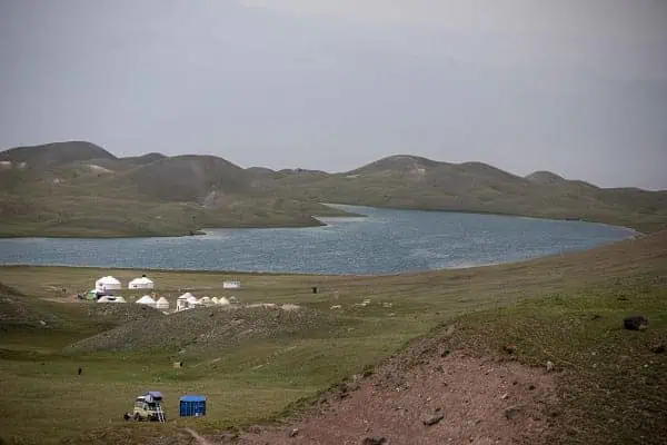
After breakfast, the driver will take you to the yurt camp at Tulpar-Kol Lake (a 1-hour drive). Leave your bags and walk to Panorama. There you will enjoy a fabulous view of the lakes and the Alay Valley. Return to the yurt camp for an overnight.
- Accommodation type: yurtcamp with twin, double, and single beds available, solar-heated water showers, and water running toilets
- Food: lunchboxes and dinner at the yurtcamp
- Electricity and network: solar-powered electricity for phone chargers, mobile network (megacom, o!, beeline), and 5 G wifi
- Driving distance: 22 km, 40 minutes
- Trekking distance: 11 km, 4 hours (excluding lunch and breaks)
- Ascend/descend: 3390/3670 meters
- Highest and lowest points: 4100/3500 meters
- Overnight altitude: 3500 meters
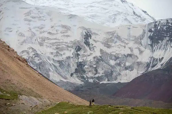
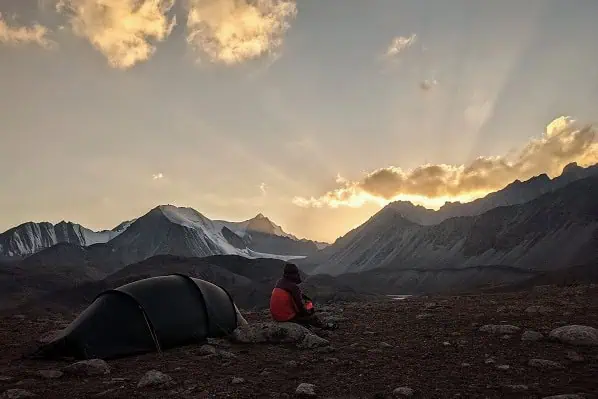
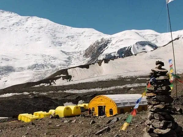
Embark on a journey from Tulparkol Lake. Hit the breathtaking Traveler’s Pass on your way, standing at an altitude of 4120 meters. After 6–7 hours of hiking, you will finally arrive at Advanced Camp, also known as Camp 1, situated at 4400m above sea level.
The camp is located in a cold, snowy environment with surrounding permafrost peaks. A sweeping panorama of the majestic Lenin Peak, towering above you like a snow titan, offers a truly incredible view. It is indeed inspiring, yet humbling to stand so close to this iconic peak.
- Accommodation type: tent on a wooden floor with a mattress (bring your sleeping bag or rent one in Sary-Mogol).
- Food: lunch boxes
- Electricity and network: no mobile network, 5G startlink wifi is available
- Trekking distance: 14 km, 7 hours
- Ascend/descend: 1020/140 meters
- Highest and lowest points: 4480/3500 meters
- Overnight altitude: 4400 meters
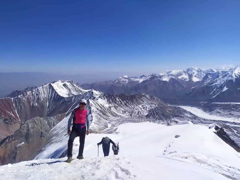
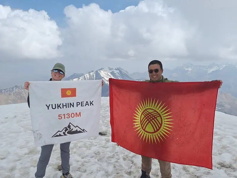
After breakfast, begin your ascent to Peak Yukhin, standing at an impressive altitude of 5130 meters. This is one of the best acclimatization peaks, allowing climbers to reach the summit without crampons or ropes. However, the climb demands significant physical effort and determination to reach the top.
Upon successfully reaching the summit, take a moment to enjoy the breathtaking views and capture memorable photos. Have lunch before descending back to Tulparkol. Stay overnight at the yurt camp, or drive directly from Tulparkol to Sary-Mogol and rest at the guesthouse.
- Accommodation type: yurtcamp or guesthouse (as described above)
- Food: lunch boxes upon ascent and dinner at the yurt camp or guesthouse
- Electricity and network: electricity is available, mobile network (megacom), and wifi
- Trekking distance: 19 km
- Ascend/descend: 670/1700 meters
- Highest and lowest points: 5100/3500
- Overnight altitude: 3500 meters (Tulparkol) or 2976 meters (Sary-Mogol)
Your epic odyssey is coming to an end. Enjoy your breakfast and take a scenic drive back to Osh via the picturesque Alay Valley. The total distance is 220 kilometers, and the drive will last for about 3.5 hours (from Sary-Mogol).
- Accommodation type: We can help with booking your accommodation in Osh upon request.
- Food: breakfast at the yurt camp/guesthouse, lunch along the road
- Electricity and network: electricity is available, mobile network (megacom), and wifi
- Driving distance: 220 km, 3.5 hours
- Highestwifi lowest points: 3500/960 meters
- Overnight altitude: 960 meters
Contact to book or ask your questions!
Dear travelers, we are currently experiencing PROBLEMS WITH CONTACT FORMS. If you've sent a request and haven't received a reply within a day, please consider alternative channels (WhatsApp, Telegram, or email).
Related Options:
- Fastest way to conquer the Yukhin Peak
- Drive through the scenic Alay Valley
- Nomadic and rural lifestyles
- Alternative start from Kojo-Kelen village
- Epic sceneries of the titanic Alay mountains
- Return through scenic Alay valley