Highlights of the trip
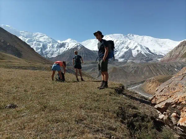
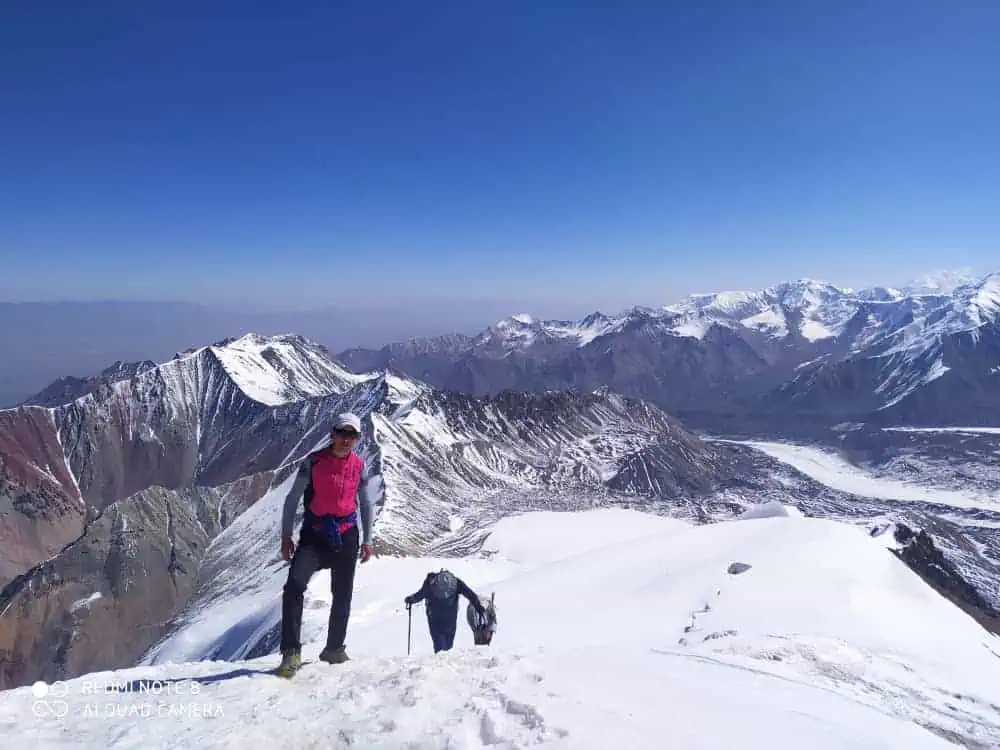
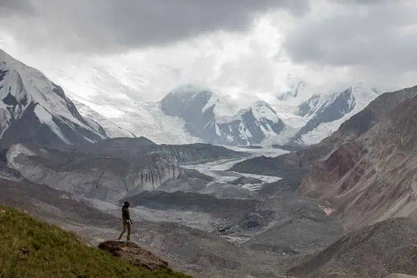
- Epic sceneries of the titanic Alay mountains
- Prestine nature
- Nomadic and rural lifestyles
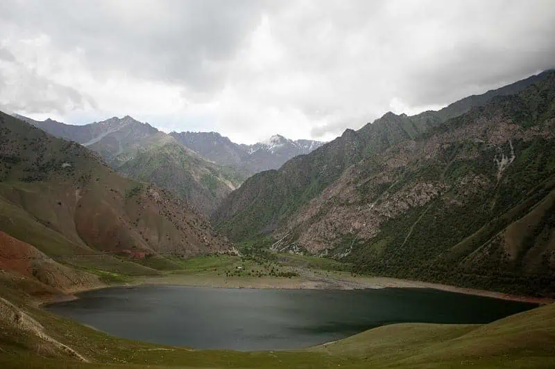
- Turquoise lakes and waterfalls
Tour Details
Available
June (mid) - Early September
Schedule
Upon request
Duration
5 days (3 days of hiking)
Price
upon request
Difficulty
Moderate - challenging
Required items
Check the FAQ section
Itinerary
Route map
Neccessary items
Why choose us?
Itinerary
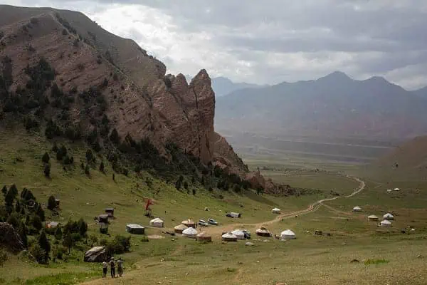
Day 1: Osh City — Sary-Mogol Town
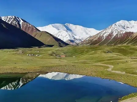
A morning departure from Osh to Sary-Mogol through the scenic Alay mountains and valley. Detour to visit the Kolduk lake – a beautiful mountain lake, located to the east of Kolduk village. The lake’s surface beautifully reflects the pair of cliffs with the surrounding plants and fir trees. Walk around the lake, take photos, and enjoy the expansive view before continuing to Sary-Mogol. Arrival in Sary-Mogol, lunch, and walking around the village—dinner and overnight at the guesthouse.
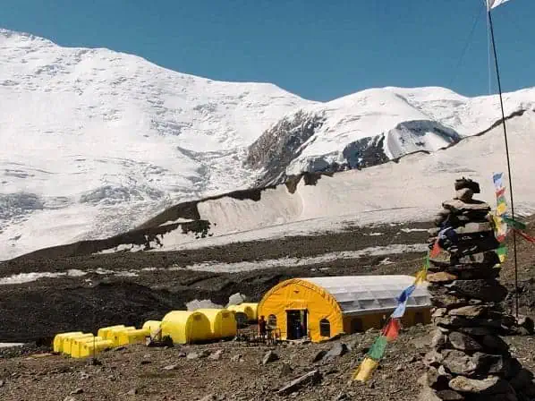
Day 2: Sary-Mogol Town via Sary-Mogol Pass to the yurt camp.
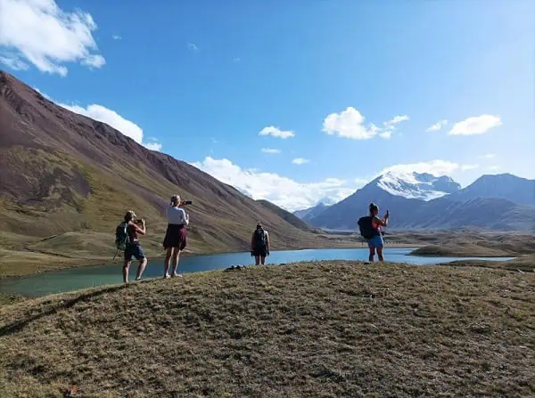
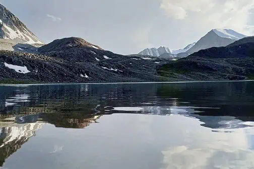
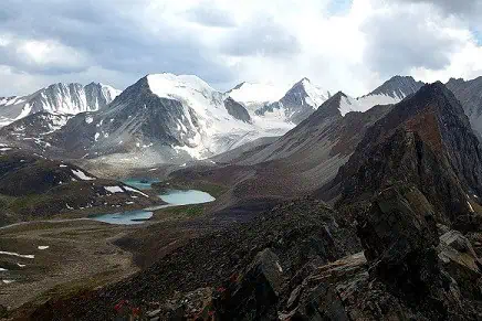
Heading to the starting point of the trek from Sary-Mogol (1h of driving). The trek begins with a challenging ascent to Sary-Mogol Pass (4270 m). After 6-8 hours of trek through the rocky path, you will be rewarded with a stunning scenery of the Beshkol lakes. Enjoy the views before heading further to the yurt camp for an overnight stay.
- Trekking distance: 14 km. (8.70 miles)
- Time of hiking: 6 hours (excluding the driving time)
- Ascent/Descent: 910/790 meters
- Highest and lowest points: 4270/3380 meters
- Accommodation altitude: 3382.00 Meters (11095.80 Feet)
- Utilities: No electricity, no internet, and no signal (power bank is recommended)
Despite the lack of roads and limited infrastructure, local families set up yurts and offer overnight stays (shared living) with a flush toilet to make your time as comfortable as possible.
Day 3: Walking to Koshmoinok (6 hours)
On the second day, your adventure follows the river, descending towards the end of a beautiful mountain gorge. Grandiose views of the Kichik Alay mountain range will accompany you all the way to a small village before you turn right onto the dirt road. After 2–3 hours, you will arrive at the small village of Kyzyl-Chara and stop for lunch at a local homestay or cafe. After lunch, you go further to the yurt camp in Koshmoinok.
- Trekking distance: 18km (11.18 miles)
- Hiking time: 7h (excluding lunch and break time)
- Ascent/Descent: 830/1460 meters
- Highest and lowest points: 3467 /2467 meters
- Accommodation altitude 2822.00 Meters | 9258.53 Feet
- Utilities: No electricity, no internet, and no signal (power bank is recommended)
Despite the lack of roads and limited infrastructure, local families from Kyzyl-Shoro village (Begali and Nurdoolot) installed a solar (water) heater, a shower, and a running toilet. They have two shared yurts and a dining hut.
Day 4: Koshmoinok to Kojo-Kelen village (6 hours).
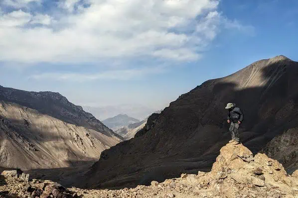
Another day filled with epic panoramic views and pristine nature of Sary-Bel Pass (3150m), decorated with the sounds of birds and rushing rivers. The trail will lead you to the picturesque village of Kojo-Kelen, renowned for its red rock formations and authentic charm. The village will welcome you with renowned Kyrgyz hospitality at a cozy local homestay. After settling, you will discover the signature sights of Kojo-Kelen. The first is a waterfall: a hidden cascade that offers a refreshing ambiance, perfect for relaxation and photography. Second is the Blue Cave Pool—a wonderful spot where the turquoise water glows within a natural cave—ideal for a quick dip or simply admiring.
Culminate your evening with a stroll around the village, immersing yourself in the peaceful rural lifestyle, before enjoying a hearty dinner featuring local dishes.
- Trekking distance: 10 km (6.50 miles)
- Hiking time: 6h (excluding lunch and break time)
- Ascent/Descent: 340/960 meters
- Highest and lowest points: 3127 /2230 meters
- Accommodation altitude 2230.00 Meters | 7316.27 feet
- Accommodation type: local homestay with shared rooms on the traditional floor, blankets, a hot shower, and a flush toilet.
- Utilities: there is electricity and Wi-Fi
Day 5: Kojo-Kelen – Return to Osh (95 km, 3 hours of driving).
Return to Osh after breakfast along a dirt road, with more scenery of nature’s beauty. Take a chance to stop at the Papan Reservoir for photos of the turquoise waters against a backdrop of mountains. Get an additional glimpse into traditional Kyrgyz villages, with rural life and the charm of remote mountain settlements. Arrive in Osh and explore the highlights of Kyrgyzstan’s oldest city with guided tours.
Route map
Neccessary items
Here are the recommended items to make your Heights of Alay comfortable.
- Warm clothing that comes in layers. As mentioned above, temperatures range from 25 degrees down to 0, and sometimes below freezing. Being able to put on and take off clothes upon request is crucial to avoid heat loss, sweating, and energy loss. Pay particular attention to reliable, water- and windproof light jackets and pants that will protect from rain, wind, and strong sunlight in the mountains. A down jacket with its superior warmth-to-weight ratio will add more heat to your overnight stays without adding a burden to carry. For the comfort of your feet on varying terrain, ascents, and descents, bring good hiking shoes.
- Personal hygiene and medical kit. In addition to your basic hygiene items, we recommend bringing wet wipes and antiseptic hand gel. Lipsticks or balms for lips, as the sun and wind will easily affect them. A medical kit should include pills for diarrhea, headaches, altitude sickness, blisters, and other minor illnesses.
- To stay hydrated, you need a refillable water bottle (best if it has an installed filtration) instead of carrying plastic bottles. Pack the water purifying pills or powder in case of drinking the water from a spring.
- Skin protection. Protect your skin and eyes from the sun using the combination of sunglasses, sunscreen (SPF with higher digits), and a hat.
Why choose us?
- Arranging with locals. While developing, planning and arranging the experiences we involve solely the local guides, drivers and other vendors in the region. First the locals know their area better than anyone else. Second, they are the ones who should benefit from the economic and social opportunities provided by tourism. Third, they are interested the most to preserve the nature and culture of their habitat. And last, but not least, hiring the locals directly reduces the supply chain, which in turn brings to …
- Competitive prices. Thanks to working with locals, we manage to avoid intermediary costs that increase the cost for travelers and might reduce the revenue for locals. Thus, we offer one of the best prices in the market. Whether you need a full package or partial services during your hike, we will advice and assisst you with arranging your trip with a competitive offer.
Contact to book or ask your questions!
FAQ and tips
We arrange both options. There are pros and cons of both options, but no matter which you choose, we provide the experience of local guides, reliable drivers, and accommodation and meals. The price varies based on the number of participants and services included. Hence, feel free to request the suitable option, and we will reply promptly.
On the one hand, we evaluate the Height of Alay treks as moderate to challenging, with elevations of 4200-4300 meters and steep ascents and descents over rocky, scree-covered terrain. On the other hand, the travelers, knowing this information, must thoroughly evaluate their physical condition and prior high-altitude trekking experience. Even the experienced hikers should consider spending a night in Osh city (just under 1000 meters asl) and maybe taking day trips to nearby mountains at lower altitudes. Increasing your hydration upon arrival and bringing altitude sickness pills are other good ideas.
Triple meals are provided along the trek. Breakfasts and dinners are usually served at the yurtcamps and homestays, while lunches are either at the yurtcamps, homestays, village cafes, or in lunchboxes. Please let us know in advance if you have dietary restrictions.
Water is available along the route. Thanks to the mountain springs, you can refill your bottles, while the yurt camps and homestays can either provide boiled water or purchase and transport bottled water from the urban area. No matter what, we strongly insist that you bring purification filters or purification pills (powder) to purify water from rivers and springs. It can also be a bottle with an installed filtration system. Take all possible measures to stay hydrated along the route.
Accommodation is provided at homestays and yurtcamps. Depending on your itinerary and location, utilities, comfort, and network availability may vary. Whether the yurtcamps have mobile connection, internet, hot showers, running water, toilets, and electricity is usually highlighted in the itinerary. Despite highlighting it in a “necessary items ” section, we strongly recommend you bring reliable power banks and wet wipes.
The best season for most of the Alay mountains trek is mid-June to mid-September. This time of year, daytime temperatures range from +20 to +25 degrees Celsius, while nighttime temperatures fall to +5 to 15 degrees at night. In case of rain, the temperature at night might fall to 0. Other factors may affect temperatures in the mountains, and the best way to be ready for temperature variations is to wear layered clothing. Despite the average heat in the mountains, don’t forget about the sun’s effect on high altitudes. Bring proven, reliable skin and eye protection.
If somehow you visit Kyrgyzstan during a time that falls outside the range of the best hiking season, don’t despair. Whether it is a bit earlier (let’s say, end of May, beginning of June) or later (end of September), we can adjust to your needs, given the prevailing challenges and the added adventure.
Here are the recommended items to make your Heights of Alay comfortable.
- Warm clothing that comes in layers. As mentioned above, temperatures range from 25 degrees down to 0, and sometimes below freezing. Being able to put on and take off clothes upon request is crucial to avoid heat loss, sweating, and energy loss. Pay particular attention to reliable, water- and windproof light jackets and pants that will protect from rain, wind, and strong sunlight in the mountains. A down jacket with its superior warmth-to-weight ratio will add more heat to your overnight stays without adding a burden to carry. For the comfort of your feet on varying terrain, ascents, and descents, bring good hiking shoes.
- Personal hygiene and medical kit. In addition to your basic hygiene items, we recommend bringing wet wipes and antiseptic hand gel. Lipsticks or balms for lips, as the sun and wind will easily affect them. A medical kit should include pills for diarrhea, headaches, altitude sickness, blisters, and other minor illnesses.
- To stay hydrated, you need a refillable water bottle (best if it has an installed filtration) instead of carrying plastic bottles. Pack the water purifying pills or powder in case of drinking the water from a spring.
- Skin protection. Protect your skin and eyes from the sun using the combination of sunglasses, sunscreen (SPF with higher digits), and a hat.
If your trekking tour falls during the peak season (mid-June to mid-September), you do not need sleeping bags or tents. If we arrange your trek for late spring, early summer, or late autumn, you might need tents and sleeping bags, since the yurt camps won’t be there and the weather can get cold. On top of that, there will be a certain necessity to hire porters to carry additional items. Nevertheless, you can rent tents, sleeping bags, and other items in Osh or Sary-Mogol. As of walking sticks, you are welcome to have them to ease your hike.