Highlights of the trip
Take a once-in-a-lifetime journey to the roof of the world — an odyssey carved through the sky-high Pamir Mountains. But take this journey if you have a Spartan mind and spirit, as it is not a typical tour. It is an adventure that immerses you in raw nature, ascetic ways of life, towering mountains, and crystal-clear alpine lakes. You will get a glimpse and maybe even hear the whispers of ancient caravans that risked it all for unimaginable fortunes of the Great Silk Road. You will witness the majesty of a pristine nature, so untouched, seeming otherworldly. And you will interact with Kyrgyz and Pamiri highlanders – warm-hearted and philosophically resilient people of the mountains. So if you seek primordial freedom, thrilling discoveries, and mystics of the unknown, Pamir is waiting for you.
Tour Details
Available
April-November
Schedule
Upon request
Duration
10 days (customizable)
Price
upon request
Difficulty
moderate to challenging
Required items
Trekking boots (+light shoes), weatherproof warm clothes, hat, gloves, sunscreen, sunglasses
Itinerary (click to unfold the description)
Meeting at the hotel at 9-9.30 AM.
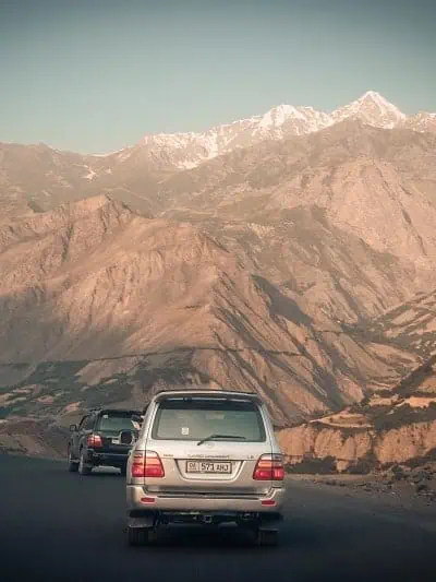
Your journey along the Pamir Highway begins in Dushanbe and leads you through the “Western Pamir Highway,” built in 1940. The good news is that the government has recently reconstructed this old Soviet road, and your ride will be more comfortable than your predecessors’. On your journey to Khalaikhumb, you will make two stops: at the Nurek water reservoir – the second-highest hydropower station in the world, and the 11th-century Fortress of Hulbuk.
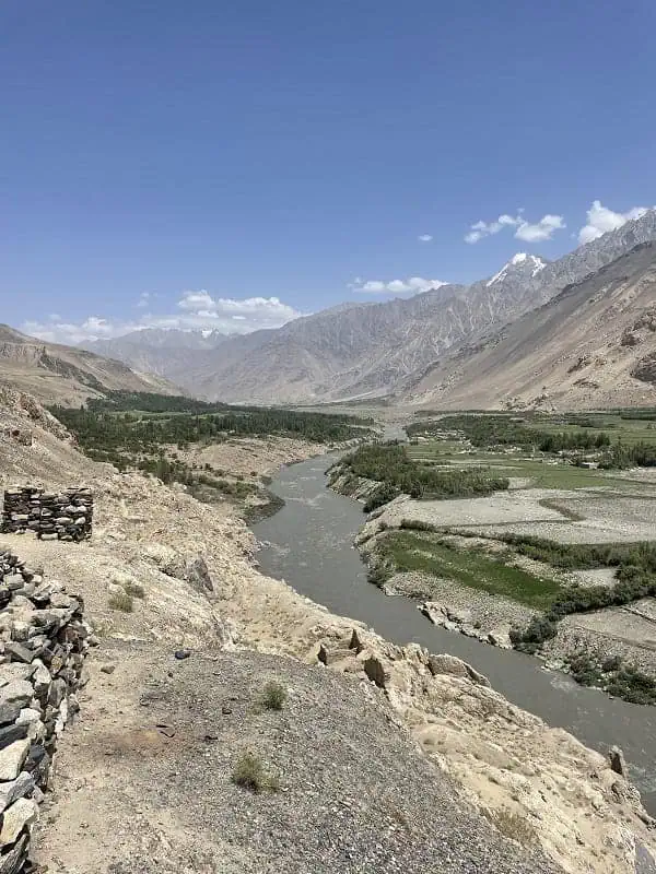
Enjoy lunch in Kulab before continuing your journey through the deep rocky valleys and stunning mountains that lead to the Shurobod Pass. There, you will officially enter the Gorno-Badakhshan Autonomous Oblast (GBAO) by crossing the military and police checkpoints. By driving further along the Pianj River, you will witness the exotic Afghan villages across the border. In a few hours of driving, you will reach Kaliaikum (Darvoz) for your first overnight stay, dinner, and Accommodation at the homestay ROMA.
- Driving distance/hour: 352km / 219 mi – 6 hours
- Altitude: 1200 m / 2,297 ft
- Internet: Tcell (4G), Megafon (4G), Wi-Fi
- Electricity: Available
- Facilities: Guest house, private shower, western toilets, and twin rooms for 2 people.
Hiking elevation 429 meters (2066m-2495m)
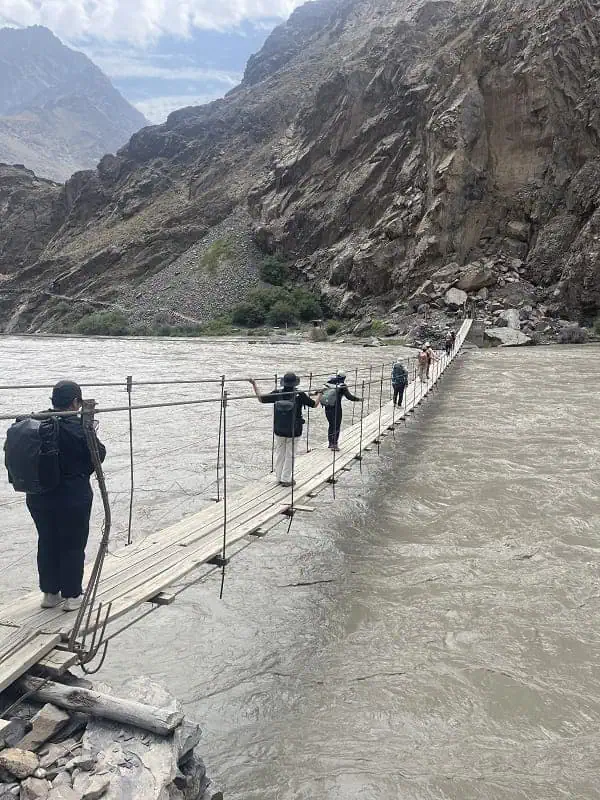
You continue your trip along the Pianj River, driving towards the Bartang valley. There, from the “Bridge”, you will start your hike to the remote Jizev village. The round-trip hike is 5-6 hours. The ascent to the village takes 3 hours; afterward, you will spend time there taking photos and sipping tea with the local family. After you return to the car and drive to Khorog, the administrative center of GBAO. Overnight at the Hotel TEM.
- Driving distance/hour: 344 km, 5-7 hours
- Altitude: Hiking elevation 429 meters (2066m-2495m)
- Internet: No mobile coverage during the hike, but Wi-Fi is available in Khorog.
- Electricity: available.
- Facilities: Private hotel shower, Western-style toilets in the room. and a twin room for 2 people.
Have your filling breakfast before heading to explore the Khorog’s unique Botanical Garden, filled with a diversity of plants. Depart to Ishkashim via Garm Chashma hot springs. Lunch will be at Garm Chashma hot springs. After lunch, you may visit the hot springs before continuing to Ishkashim in the Wakhan Valley—dinner and overnight at the Davlator guest house.
- Driving distance/hour: 145 km / 98 mi, 4–5 hours
- Altitude: 2,200 m / 7,218 ft
- Internet: Tcell (4G), Megafon (4G), Wi-Fi
- Electricity: Available, Limited
- Facilities: Shared indoor shower and western toilets at the homestays. 3 twin rooms and 1 triple room.
Enjoy your breakfast before setting out on the side trip to the Khaaka fortress. Bear the epic Hindu Kush Mountain Ranges from your windows. A second fortress you will stop at is the 12th-century Yamchun Fortress, which stands atop a natural rock. Walk up to the edge of the fort to have a panoramic view over the Wakhan Valley. Further up the hillside, there are Bibi Fatima hot springs with crystal-clear water rich in minerals. Back to the main road. Overnight and dinner in a friendly homestay in Langar Village.
- Driving distance/hour: 135 km / 88 mi, 4–5 hours
- Altitude: 2,200 m / 7,218 ft
- Internet: Tcell (4G), Megafon (4G), Wi-Fi
- Electricity: Available
- Facilities: Shared indoor shower and western toilets at the homestays. Shared rooms for up to 4 people.
Hiking elevation 96 meters (4214m-4310m)
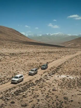
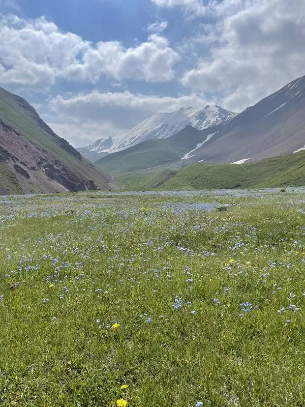
Another day filled with stunning mountain scenery in the Grand Pamir Mountains on the Afghan side. There is a good chance of seeing the real nomadic Afghan-Kyrgyz caravans (yes, Kyrgyz people are all around the world). The Kargush military checkpoint indicates you are exiting the Wakhan Valley and heading up to the Kargush Pass (4,344m), which brings you back to the main road of M41. Visit the Alpine Bulunkul and Yashylkul lakes (you will need to purchase entrance tickets to Yashylkul National Park, which are not included in the price). Arrive at Maljuran Hot Springs Yurt Camp for dinner and accommodation.
- Driving distance/hour: 240 km/ 149 mi/ 5 hours
- Hike: 3–4 hours, reaching 4,310 m / 13,748 ft
- Internet: No mobile coverage
- Electricity: Solar Panels 12V, only for charging phones
- Facilities: Shared indoor pool, outdoor western, and squat toilets at the Yurt stays. Shared rooms for up to 4 people.
Hiking elevation 182 meters (4110m-4292m)
Embark on a 5-hour drive to Murgab via Alichur village, with stops at Ak Balyk Lake, and later hike to the old Russian observatory built in the Soviet era. Behold the grandiose Mustag-Ata glacier located in China (of course, if the weather allows it). Have some snacks, then head further to Murgab for a late lunch and a rest. In your free time, you can wander around and explore the town, have dinner, and overnight in an Erali Guest House.
- Driving distance/hour: 282 km / 219 mi – 5-6 hours
- Altitude: Murgab 3600 m / 12,631 ft
- Internet: available in Murgab. Megafon 4G, Wi-Fi.
- Electricity: Available
- Facilities: Shared outdoor shower, outdoor western, and squat toilets at the homestays. Shared rooms for up to 4 people.
Hiking elevation 678 meters (4064m-4742m)
Have your breakfast and don’t forget to grab some snacks for your hiking picnic at Gumbozdu Kol Pass (4800m). The driver will drop us at Gumbozdu Kol George, and in 5-6 hours, will pick us up from the Madian side. Drive back to the same guesthouse in Murgab to reward your efforts with a hot shower and a rest with a cup of green tea.
- Driving distance/hour: 120 km/145mi – 2 hours
- Hike: 4–5 hours, reaching 4742 m / 15,748 ft
- Altitude: 3600m – 4742m / (Gumbozdu Kol Pass)
- Internet: No internet available during the hike.
- Electricity: Available in Murgab
- Facilities: Traditional local home with shared shower and toilet.
Today is your last day in Tajikistan as you head to Kyrgyzstan. You will pass the highest pass of the Pamir Highway – Ak-Baital Pass, standing at 4,655 meters. Besides the highest pass, this day grants you the presence at the largest lake in the Pamir – Karakul Lake. Glaciers formed Karakul, which has no outflow. Take your chance to walk around the lake, take your photoshoots, and have lunch. After lunch, you will head to the Tajik-Kyrgyz border at Kyzylart Pass, standing at 4,288 meters. A different landscape indicates that you are in Kyrgyzstan. Arrive in Sary-Mogol village, have dinner, and stay overnight at a guest house or hotel.
- Driving distance/hour: 250 km/155mi – 6 hours
- Altitude: 3500 m /
- Internet: MEGA Kyrgyzstan LTD.
- Electricity: Available, Limited
- Facilities: Private hotel shower; Western-style toilets in the room. Rooms for 2 people, Twin room. Traditional yurts with outside shared showers and toilets.
Hiking elevation 630 meters (3500m-4130m)
Breakfast at 8.00 am and a one-hour drive to the yurt camp at Tulparkol Lake (3500 m) next to Lenin Peak Base Camp. After settling in, enjoy the scenery and hike to the viewpoint at 4,130 meters. The 3-hour ascent offers breathtaking views of glaciers tumbling down from Lenin Peak. After resting at the pass, have lunch before returning to the yurt camp (2 hours). Enjoy your rest and have a cup of hot tea before another optional walk around Tulparkol Lake. We can also arrange a horse ride upon request. Overnight at the yurtcamp.
- Driving distance/hour: 25 km/40 minutes
- Hike: 5-6 hours, reaching 4,130m / 13,550 ft
- Altitude: 3500 m /
- Internet: MEGA Kyrgyzstan LTD.
- Electricity: Available, Limited
- Facilities: Traditional yurts with shared outdoor showers and toilets.
Your epic journey along the Pamir Highway is coming to an end. Yet it is not over, as you have a scenic drive to Osh through the Alay Mountains and Valley. You are welcome to make a brief stop at the Uch-Dobo viewpoint for some photos. Upon arrival, we will go to the local café, where Atabek will arrange lunch. After lunch, we will take you to your hotel for check-in and finish our trip with farewells.
- Driving distance/hour: 250 km/ 155mi / 5 hours
- Internet: Mega, Wi-Fi
- Electricity: Available
- Facilities: Hotel in Osh.
Nearest guaranteed departures
| Programm | Dates | Seats available | Price |
| Osh – Dushanbe Pamir Highway (7 days) | June 12 – June 18 | 4 out of 4 seats are available | $400/seat |