Highlights of the trip
- Conquer one of the favorite acclimatization peaks
- Epic sceneries of the titanic Alay mountains
- Prestine nature
- Nomadic and rural lifestyles
Discover one of the best trekking routes in the trekking utopia of Central Asia that culminates with the conquest of Yukhin Peak – one of the best acclimatization peaks and get a close-up view of Lenin Peak. Don’t miss the opportunity to experience the high-altitude beauty of the Pamir Mountains.

Tour Details
Available
June (mid) - Early September
Schedule
Upon request
Duration
6 days
Price
upon request
Difficulty
Challenging
Required items
Trekking boots (+light shoes), weatherproof warm clothes, hat, gloves, sunscreen, sunglasses, sleeping bags
Itinerary (click to unfold the description)
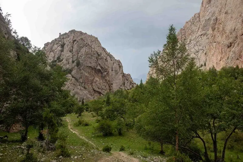
Welcome to Osh. See you at the airport or at your hotel before you depart for Kojo-Kelen village. The beauty of Kyrgyzstan’s nature is evident from the moment you see its exotic mountains, flora, and fauna. The road will take you along the Papan reservoir, the main source of drinking and irrigation water in Osh. After 3.5 hours of driving, you will reach the Kojo-Kelen (2230 meters). A welcoming lunch will be waiting for you upon arrival, before you head out for an acclimatization hike (2-3 hours). You will visit the Blue Grot and the waterfall. Return to the guest house for dinner and overnight.
- Accommodation type: homestays with shared rooms and traditional floor mattress beds; hot shower and water running toilets
- Food: homemade lunch and dinner at the guesthouse
- Electricity and network: electricity is available, mobile network (megacom), and wifi
- Driving distance: 95 km, 3 hours
- Ascend/descend: 2260/1050 meters
- Highest and lowest points: 2230/980 meters
- Overnight altitude: 2230 meters
Wake up to fresh and clean mountain air. Enjoy breakfast (served at 08:00), pick up your lunch boxes, and hand over your heavy luggage to the porters. Begin your trek by walking along the pristine, rushing Ak-Buura River, which supplies water to Osh and downstream settlements. Unique mountain formations, juniper forests lining both sides of the trail, and untouched landscapes will accompany your hike. The owners of the yurt camp at the foot of Jiptik Pass will welcome you with a dinner upon arrival. Dinner and overnight at the yurtcamp.
- Accommodation type: Yurt (traditional mattress on the floor, no beds, 3-4 people per yurt)
- Food: lunch en route and dinner prepared by the yurt hosts.
- Electricity and network: No electricity, internet, or signal (a power bank is recommended)
- Trekking distance: 14 km (8.7 miles), 5 hours excluding lunch and breaks
- Ascend/descend: 1000/10 meters
- Overnight altitude: 3,040 meters
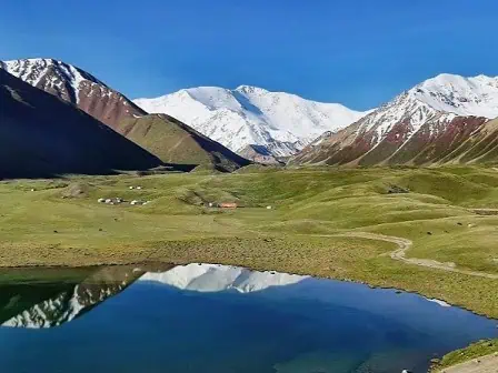
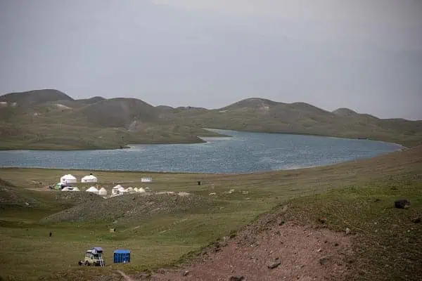
Get your filling breakfast (08:00) and begin the ascent to the Jiptik Pass (4,185 m) along the trail that follows an old Soviet-era road. The climb pass takes about 3 hours. Enjoy the breathtaking views of the snow-covered Pamir-Alay Mountains, with Lenin Peak (7,134 m) as the highlight. Descend from the pass via an old auto trail toward the Darbaza-Tash (“Stone Gates”), where the driver will transfer you to the yurt camp at Tulparkol Lake.
- Accommodation type: yurt (3-4 beds per yurt, with the possibility to arrange twin/double accommodation), solar-heated water showers, and water running toilets
- Food: lunch en route and dinner prepared by the yurt hosts.
- Electricity and network: Electricity and network: solar-powered electricity for phone chargers, mobile network (megacom, o!, beeline), and 5G wifi
- Trekking distance: 15 km, 5 hours on foot; 10 km – 30 minutes of driving (excluding lunch and breaks)
- Ascend/descend: 830/1,230 meters
- Overnight altitude: 3,500 meters
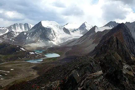
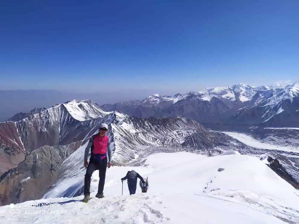
Embark on a journey from Tulparkol Lake. Hit the breathtaking Traveler’s Pass on your way, standing at an altitude of 4120 meters. After 6–7 hours of hiking, you will finally arrive at Advanced Camp, also known as Camp 1, situated at 4400m above sea level.
The camp is located in a cold, snowy environment with surrounding permafrost peaks. A sweeping panorama of the majestic Lenin Peak, towering above you like a snow titan, offers a truly incredible view. It is indeed inspiring, yet humbling to stand so close to this iconic peak.
- Accommodation type: tent on a wooden floor with a mattress (bring your sleeping bag or rent one in Sary-Mogol).
- Food: lunch boxes
- Electricity and network: no mobile network, 5G startlink wifi is available
- Trekking distance: 14 km, 7 hours
- Ascend/descend: 1020/140 meters
- Highest and lowest points: 5100/3500 meters
- Overnight altitude: 4400 meters
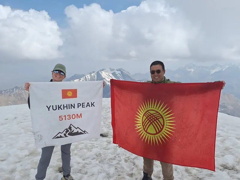
After breakfast, begin your ascent to Peak Yukhin, standing at an impressive altitude of 5130 meters. This is one of the best acclimatization peaks, allowing climbers to reach the summit without crampons or ropes. However, the climb demands significant physical effort and determination to reach the top.
Upon successfully reaching the summit, take a moment to enjoy the breathtaking views and capture memorable photos. Have lunch before descending back to Tulparkol. Stay overnight at the yurt camp, or drive directly from Tulparkol to Sary-Mogol and rest at the guesthouse.
- Accommodation type: yurtcamp or guesthouse (as described above)
- Food: lunch boxes upon ascent and dinner at the yurt camp or guesthouse
- Electricity and network: electricity is available, mobile network (megacom), and wifi
- Trekking distance: 19 km
- Ascend/descend: 670/1700 meters
- Highest and lowest points: 5100/3500
- Overnight altitude: 3500 meters (Tulparkol) or 2976 meters (Sary-Mogol)
Your epic odyssey is coming to an end. Enjoy your breakfast and take a scenic drive back to Osh via the picturesque Alay Valley. The total distance is 220 kilometers, and the drive will last for about 3.5 hours (from Sary-Mogol).
- Accommodation type: We can help with booking your accommodation in Osh upon request.
- Food: breakfast at the yurt camp/guesthouse, lunch along the road
- Electricity and network: electricity is available, mobile network (megacom), and wifi
- Driving distance: 220 km, 3.5 hours
- Highestwifi lowest points: 3500/960 meters
- Overnight altitude: 960 meters
Contact to book or ask your questions!
Dear travelers, we are currently experiencing PROBLEMS WITH CONTACT FORMS. If you've sent a request and haven't received a reply within a day, please consider alternative channels (WhatsApp, Telegram, or email).
Related Options:
- Fastest way to conquer the Yukhin Peak
- Drive through the scenic Alay Valley
- Nomadic and rural lifestyles
- Conquer one of the favorite acclimatization peaks
- Prestine nature
- Nomadic and rural lifestyles